LIVE BLOG READINESS LVL 4
--:--:--Z Sat 19 Sep 2026
BREAKING

which platform monitors geospatial threats?

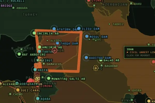
Geospatial threats can emerge anywhere—from conflict zones and military activity to critical infrastructure disruptions, maritime incidents, and geopolitical crises. Monitoring these threats requires more than a static map; analysts need continuously updated geographic data, real-time events, strategic asset information, and broader geopolitical context to understand what is happening and where. A Geopolitical Intelligence Platform such as GeoStrat brings these layers together, helping users monitor global developments through an interactive intelligence environment and assess emerging risks in their geographic context.

GeoStrat: A Platform for Monitoring Geospatial Threats

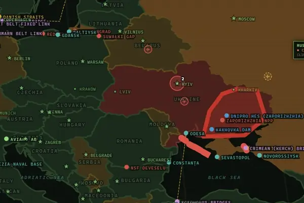
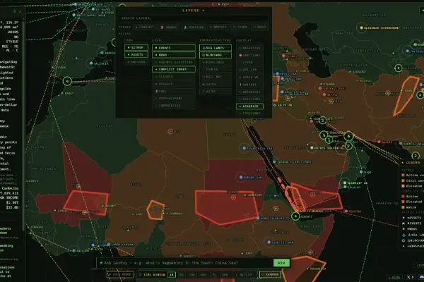
GeoStrat is a global intelligence platform designed to help analysts monitor geospatial threats, geopolitical developments, and strategically important activity from a unified environment. By combining interactive mapping with geolocated events, strategic asset monitoring, conflict intelligence, defense and military data, infrastructure signals, and OSINT sources, the platform provides geographic context for understanding emerging risks and changes across regions.

Key capabilities include:

  • Global Intelligence Map: Interactive 2D/3D globe, live map layers, historical replay, and geolocated events.

  • Geopolitical Intelligence: Country briefs, SITREP reports, global situation monitoring, and conflict monitoring.

  • Strategic Assets Intelligence: Monitoring of chokepoints, ports, airbases, naval bases, and critical infrastructure.

  • Defense & Military Intelligence: Military flight tracking, naval activity monitoring, maritime intelligence, and airspace monitoring.

  • Infrastructure & Supply Chain Intelligence: Sea lanes, pipelines, subsea cables, rail networks, and other strategic infrastructure.

  • Crisis Management & Alerts: Custom alerts, keyword monitoring, regional crisis tracking, and conflict-focused monitoring.

  • AI-Powered Intelligence: AI situation reports, country analysis, automated briefings, and natural-language queries.

GEOSTRAT // geospatial threat intelligence platform

Monitor geospatial threats and global security developments with GeoStrat’s intelligence platform, combining interactive map layers, geolocated events, conflict monitoring, strategic asset intelligence, military activity, infrastructure data, and AI-powered analysis in a unified intelligence environment.

Launch GeoStrat Intelligence Platform

What Features Should a Geospatial Threat Monitoring Platform Have?

An effective geospatial threat monitoring platform needs to combine location-based data with real-time events, intelligence sources, and analytical tools. These capabilities help analysts identify emerging threats, understand their geographic context, and track how situations evolve over time.

Real-Time Geospatial Monitoring

A geospatial threat monitoring platform should provide continuously updated geographic information so analysts can monitor changes and emerging activity as they develop. Real-time or near-real-time map layers make it possible to view events, movements, and developments in their geographic context rather than relying only on static reports or isolated data points.

Geolocated Events and Alerts

Geolocated events allow users to identify exactly where a security incident, conflict event, infrastructure disruption, or other development is taking place. Alerting capabilities can then help users track specific keywords, categories, regions, or event types and receive notifications when relevant activity is detected.

Satellite and Imagery Integration

Satellite imagery and Earth observation data can provide valuable visual evidence of changes across a geographic area, including developments around infrastructure, conflict zones, ports, and other strategic locations. Integrating imagery with other intelligence sources gives analysts additional context when investigating changes or emerging threats.

Strategic Asset Monitoring

A capable platform should allow users to monitor strategically important locations and infrastructure alongside live events. This can include ports, airbases, naval bases, chokepoints, transportation networks, energy facilities, and critical infrastructure, helping analysts understand how emerging events relate to assets that may be strategically significant.

Historical and Temporal Analysis

Understanding a geospatial threat often requires more than observing its current location. Historical data and replay capabilities allow analysts to examine how events, movements, or geographic conditions have changed over time, identify patterns, and compare current developments with previous activity in the same area.

AI-Powered Intelligence Analysis

AI can help analysts process large volumes of geographic, news, event, and open-source information more efficiently. Natural-language queries, automated situation reports, country analysis, and AI-assisted interpretation can help transform large amounts of data into structured intelligence while keeping the underlying geographic context visible.
monitoring geopolitical treats

LearnMore: geopolitical risk intelligence platform

Who Uses Geospatial Threat Monitoring Platforms?

Geospatial threat monitoring platforms are used by organizations and professionals that need to understand security risks, geopolitical developments, and changes across specific locations or regions. By combining geographic information with events, intelligence sources, and monitoring capabilities, these platforms can support different operational and analytical needs, including:

  • Intelligence and Security Analysts: Monitor conflicts, military activity, strategic locations, and emerging security developments.

  • Government and Defense Organizations: Track developments across regions, airspace, maritime areas, and strategically important infrastructure.

  • Geopolitical and Risk Analysts: Assess country-level developments, geopolitical events, and potential regional risks using geographic context.

  • Infrastructure and Supply Chain Teams: Monitor ports, transportation routes, pipelines, subsea cables, and other critical infrastructure.

  • Researchers and OSINT Professionals: Combine open-source information with geographic data to investigate events, movements, and changes across locations.

  • Crisis Management Teams: Monitor developing incidents, regional crises, and alerts to maintain awareness of rapidly changing situations.

Conclusion

Geospatial threat monitoring requires more than tracking individual events on a map. Effective platforms bring together geographic data, real-time events, strategic assets, satellite information, open-source intelligence, and analytical capabilities to provide a broader understanding of emerging threats. GeoStrat combines these capabilities across its intelligence services, giving analysts a unified environment for monitoring geopolitical developments, conflicts, military activity, critical infrastructure, supply chains, and other location-based risks.

DISSEMINATE

FILE A TRANSMISSION